Education

  • January 2022 to present

    UFSCar - LARIS

    Doctorate's Degree student in Science Computer
    Focus on machine learning to path planning

  • April 2023 to April 2024

    Linköping University

    Doctoral Exchange Program

  • February 2022 to Mars 2023

    Strm Music

    Data Scientist

  • March 2019 to August 2021

    UFSCar - LARIS

    Master's Degree student in Science Computer
    Focus on path planning to UAVs

  • March 2015 to July 2019

    UFPA - LCT

    Graduation in Computer Engineering
    Focus on telecommunication systems

  • February 2018 to July 2019

    Gracom

    School of Visual Effects

Publications

Awards

  • 2021 - First Place - 1st SARC - BARINet Aerospace Competition (CISB)

  • 2021 - First Place - RoboCup Brazil Open Flying Robot Trial League (Innovation Challenge)

  • 2021 - Second Place - RoboCup Brazil Open Flying Robot Trial League

  • 2020 - Third Place - RoboCup Brazil Open Flying Robot Trial League

  • 2020 - Second Place - Hackaton Serpro - Covid Edition

  • 2019 - Fifth Place - RoboCup Brazil Open Flying Robot Trial League

  • 2019 - Honorable Mention - Startup Weekend Belém

São Paulo, Brazil

São Carlos

55 (091) 98020 5620

Mon to Fri 9 am to 7 pm

lidiagianne@gmail.com

Send me your query anytime!

Multi-UAV Collaborative System for the Identification of Surface Cyanobacterial Blooms and Aquatic Macrophytes


Aquatic macrophyte is a generic denomination for macro-algae with active photosynthetic parts that remain totally or partially submerged in fresh or salty water, in rivers and lakes. Currently, algae monitoring is carried out manually by collecting samples to send for laboratory analysis. In most cases, harmful algal blooms are already widespread when the results are disclosed. This paper proposes the application of a team of heterogeneous Unmanned Aerial Vehicles (UAVs) that cooperate to increase the system’s overall observation range and reduce the reaction time. Leader UAV, featured with a deep-learning-based vision system, covers a pre-determined region and determines high-interest inspection areas in real-time. Through a multi-robot Informative Path Planning (MIPP) approach, the leader UAV coordinates a team of customized quadcopter (named ART2) to reach points of interest, managing their route dynamically. ART2s are able to land on water, and collect and test samples in situ by applying phosphorescence sensors. While path planning, task assignment, and route management are centralized operations, each UAV is conducted by a decentralized trajectory tracking control. Simulations performed in a realistic environment implemented on the Unity platform and experimental proof of concepts demonstrated the reliability of the proposed approach. The presented multi-UAV framework with heterogeneous agents also enables the reconfiguration and expansion of specific objectives, in addition to minimizing the task completion time by executing different processes in parallel. This preventive monitoring enables a plague control action in advance, solving it faster, cheaper, and more effectively.

Avaiable

Close Project

Dynamic Q-planning for Online UAV Path Planning in Unknown and Complex Environments


Unmanned Aerial Vehicles need an online path planning capability to move in high-risk missions in unknown and complex environments to complete them safely. However, many algorithms reported in the literature may not return reliable trajectories to solve online problems in these scenarios. The Q-Learning algorithm, a Reinforcement Learning Technique, can generate trajectories in real-time and has demonstrated fast and reliable results. This technique, however, has the disadvantage of defining the iteration number. If this value is not well defined, it will take a long time or not return an optimal trajectory. Therefore, we propose a method to dynamically choose the number of iterations to obtain the best performance of Q-Learning. The proposed method is compared to the Q-Learning algorithm with a fixed number of iterations, A*, Rapid-Exploring Random Tree, and Particle Swarm Optimization. As a result, the proposed Q-learning algorithm demonstrates the efficacy and reliability of online path planning with a dynamic number of iterations to carry out online missions in unknown and complex environments.

Avaiable

Close Project

Performance analysis of path planning techniques for autonomous robots


Autonomous robots can use path planning techniques to determine the optimal trajectory during the mission. These techniques can be classified as classical, meta heuristic, or machine learning-based. The choice of each technique for a mission depends on its specific requirements, such as finding the shortest path, completing the mission in the minimum time, or/and exploring the environment, among others. Therefore, the path planning algorithms analysis is essential to assist in selecting the appropriate technique. In the literature, the path planning algorithms are typically compared within the same category, and a general analysis is conducted to decide which technique to employ for a particular mission. However, this paper aims to delve deeper into the behavior and performance of these three path planning techniques. The analysis is based on simulations in various environments to understand how each technique behaves and performs, specifically focusing on computation costs, time, and path length efficiency.

Avaiable

Close Project

Overview of UAV Trajectory Planning for High-Speed Flight


The use of autonomous unmanned aerial vehicles has increased for High-Speed flights, leading to the need for improved performance. Trajectory planning is the primary approach to achieving high speeds, as it is safer and more flexible than other planning types. Some approaches include polynomial trajectories, optimization-based, search-based, sampling-based, and artificial intelligence, mainly reinforcement learning. This paper provides an overview of the main techniques for high-speed trajectory planning in UAVs and the challenges associated with them. It also describes essential UAV dynamics, control, and perception to reach high speeds. These techniques are demonstrated in several missions and environments, describing their methodologies. Finally, we discuss the open problems and potential future research directions in this field.

Avaiable

Close Project

Ziwi: indoor and outdoor planning network—framework to collection, modeling and network structure based on computational optimization and measurements


Society is increasingly connected, utilizing more data that demands greater capacity and better channel quality. Furthermore, wireless networks are being inserted into the population's daily lives. Therefore, solutions capable of transferring a high volume of data are increasingly needed. In this context, we present a framework that aims to network planning through data collection, modeling, and routers optimization in the environment. Ziwi framework can simulate wireless networks in indoor and outdoor environments with the main classical propagation models, obtain and calculate metrics and performance parameters. It is possible to measure data by cell phone and send it to the website quickly. Furthermore, it can model the data and compare with different propagation models. Also, optimize them using a genetic algorithm or permutation, choosing whether or not to consider sockets to turn on the routers and how many routers are needed to place in the environment. In addition, have a virtual reality environment aiming at greater interactivity with the data. We analyzed framework results comparing with Close-In propagation model, free space model, and statically using the root mean square error metric. Measurements were made in a real environment using the Ziwi mobile application, inserting data captured on Ziwi website to validate the framework.

Avaiable

Close Project

Path Planning Algorithms in Unknown and Unstructured Environments for UAVs


For an Unmanned Aerial Vehicle to become autonomous, it must perform actions without human interference. Regardless of its application area, path planning is required to carry out a mission. Nowadays, several applications require the UAV to operate in an unknown, 3D, and unstructured environment. Another essential point is considering the movement restrictions in the execution of the movements, where achieving smooth curves reduces the number of stops on 90 degrees curves. One observable aspect among the existing and most used techniques is” which would be the best technique to work in each of these environments”. This work aims to answer this question with a deeper analysis of all path planning categories: classic, metaheuristic, and machine learning. We develop our planner to analyze these techniques considering completeness, distance, time, CPU usage, memory usage, collision prevention, and robustness. This planner is modular, so it is possible to add new techniques and scenarios to be studied. We also performed tests in simulated and real environments.

Avaiable

Close Project

Digital Painting of Charmander


The drawing was vectorized in Adobe Illustrator from an @itsbirdy art and then the digital painting was done in Adobe Photoshop.

Close Project

3D Model (Sansol)


This 3D model was created to be part of the virtual reality environment of the company. Which is possible to drive a car and enter the company to recharge the car in a solar charging station.

Close Project

Sumo Robot (Kirito)


Kirito is the black robot above with the medal as he won the regional parao of sumo battles in 2017. The robot is autonomous and was made with arduino, analog line sensor, an infrared sensor and 18v dc motors. Your objective is to remove the other robot from the field without going beyond the white line.

Close Project

Style Transfer on Photos


With the help of the tensorflow in Python the transfer of style from an oil painting to the photo of a person was carried out. This technique serves to revive unique traits of ancient painters, like Picasso.

Below you can see the result of the deep learning.

Close Project

Game in Augmented Reality


This game was built using Unity and Vuforia. The game recognizes the Google dinosaur that uses a cowboy hat, and when it finds it opens google's game when the internet falls, but the race will be made with the hat-wearing dinosaur.

Close Project

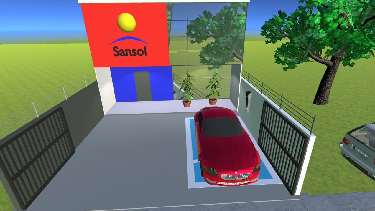
A Smart House (MyDream)


For a college job was developed a model of a smart home. In it you can control the electrical objects from the cell phone, facebook or website. If the user is not present in the room, it also has intelligence that allows it to be controlled according to the weather conditions. Like when the user leaves the house in the morning and leaves the window open, his work is not raining, but the house is, so the house can detect the rain and close the window automatically.

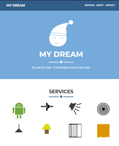
Below is the image of the website, which was built with HTML, CSS and Javascript. Using the free 000webhost server. On site you can turn on and off the electrical components. In addition to see if they are on or off (closed / open) in real time.

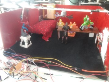
Below is the image of the model of the smart room, which was built using the Wemos D1, because it has an internet connection.

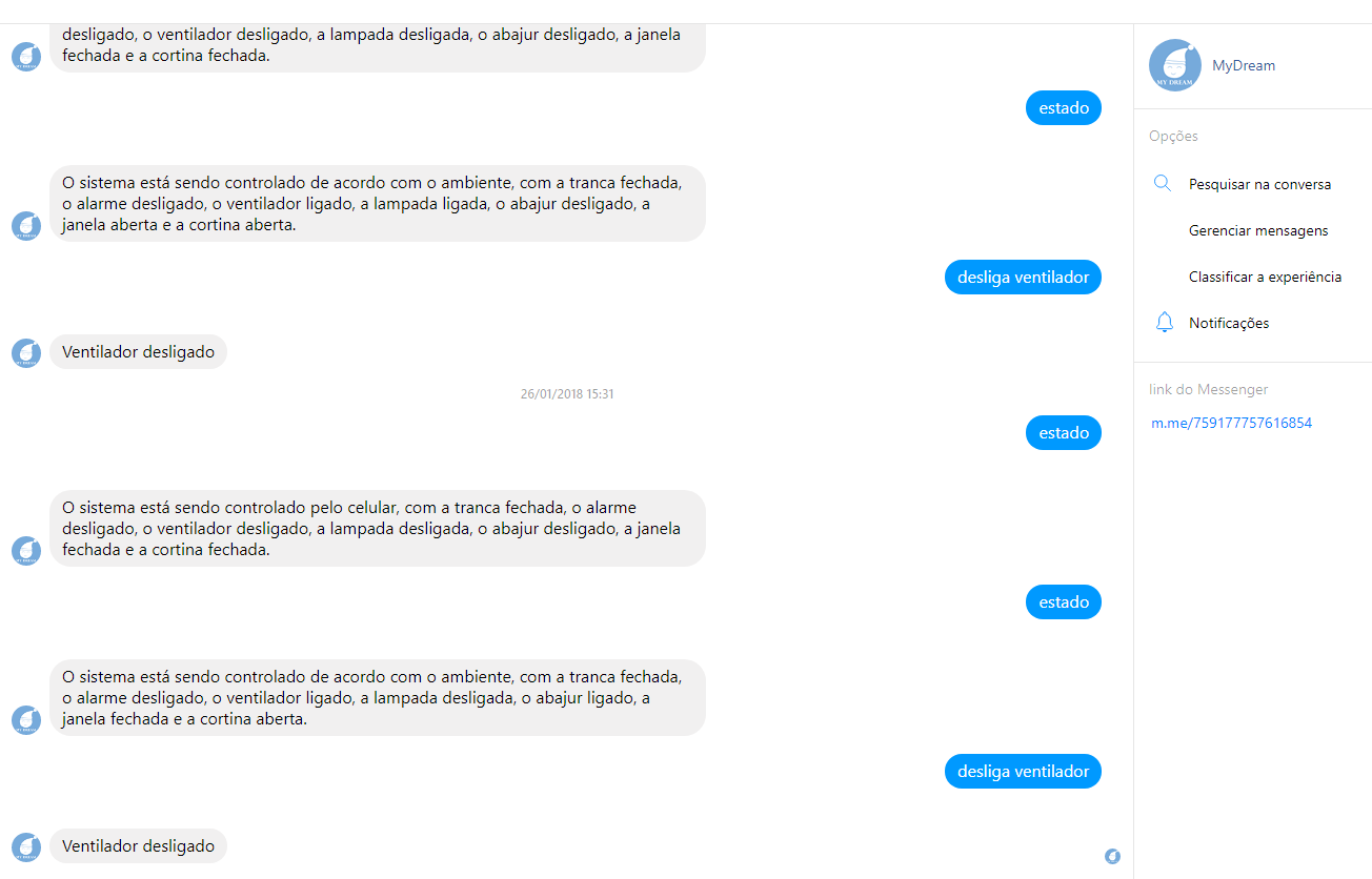
Below is the facebook chatbot image, which was built using the node.js framework and the code was uploaded to the free Glitch server. Chatting with the chatbot enables the electrical components to be switched on and off. In addition to see if they are on or off (closed / open) in real time.

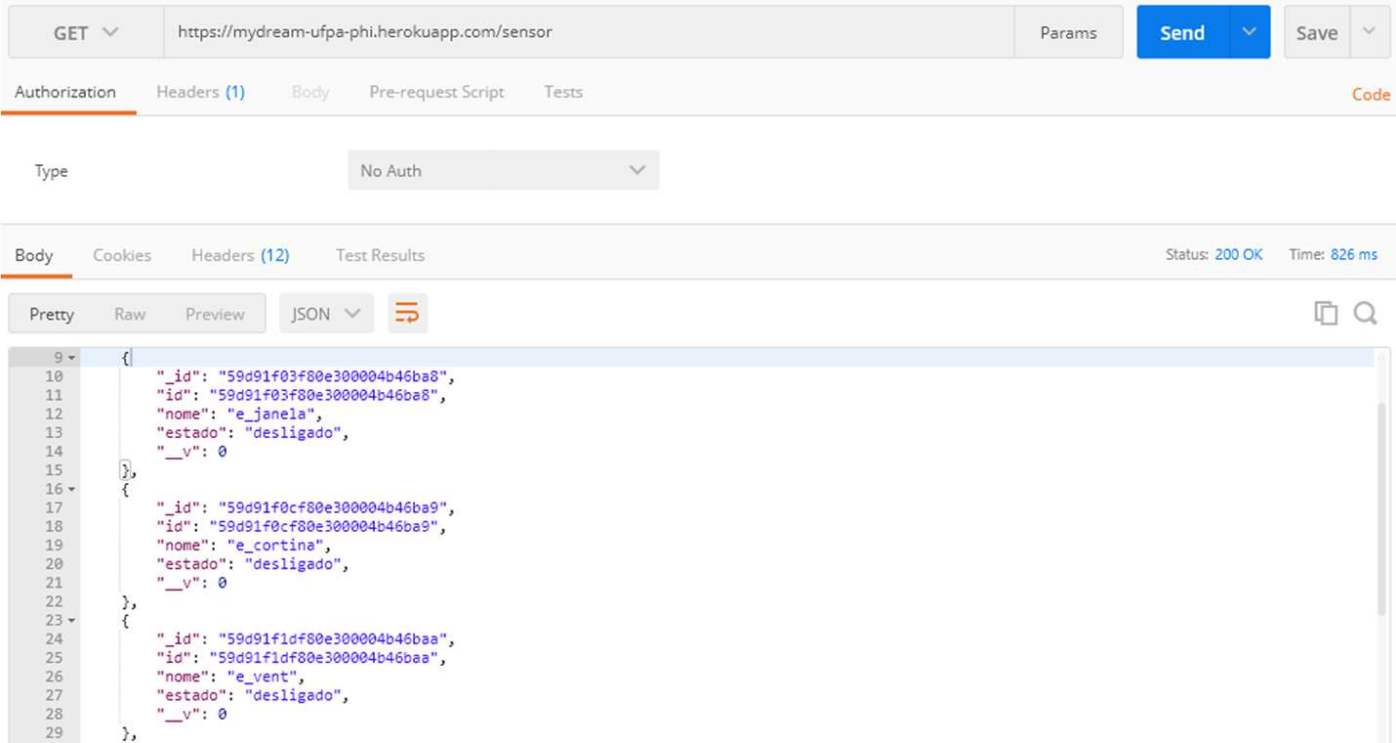
Below is the server image, which was built with the node.js framework and was uploaded to the free Heroku server.

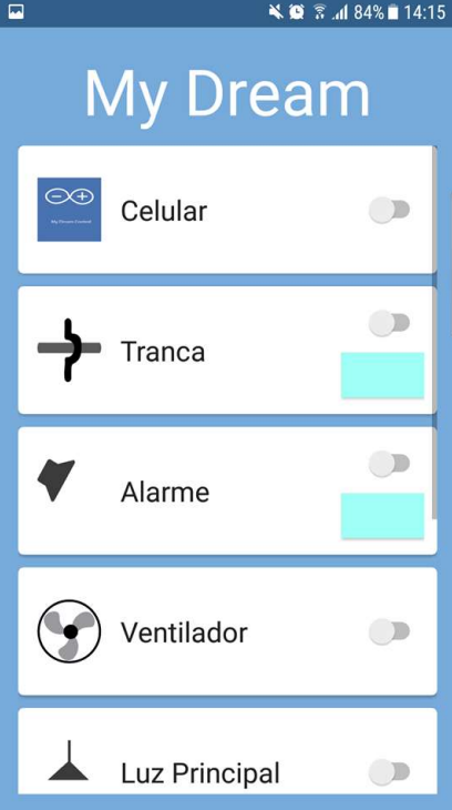
Below is the image of the mobile application, which was built using the Java programming language in Android Studio. With the application it is possible to connect and disconnect the electrical components. In addition to see if they are on or off (closed / open) in real time.

Close Project